


(by Jackie Cheung)

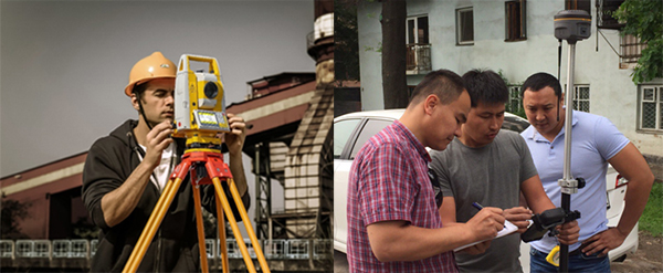
As universally known to all, land surveying is the fundamental part of earthworks engineering and infrastructure construction. And definitely, total station and GNSS receiver are the most commonly seen measuring tools on the market as the major conventional survey equipment. However, such 2 types of instruments have certain limitations, for example, sometimes surveyors might suffer much from poor intervisibility with total station while continuous satellite signal loss is a fatal problem to the use of GNSS devices. Moreover, there are still some private zones prohibited to enter, or even places hard to reach (eg. cliff) or hard to move in (eg. muddy land, swarm area), and places with insect bite and wild animals attack.

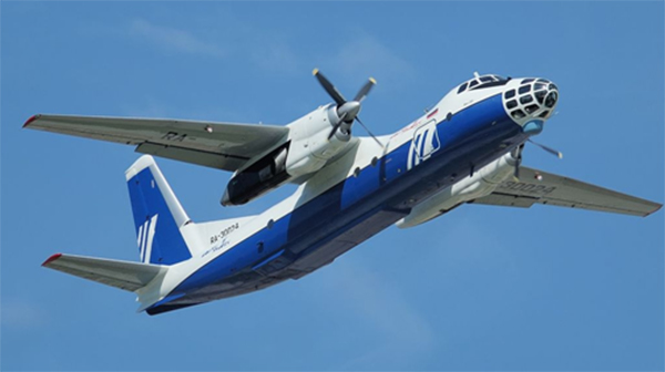
Meanwhile it’s impractical to utilize manned aircrafts for aerial photogrammetry very often or just for a small land parcel, as the vehicle rental and fuel costs can quickly run into five figures of U.S. dollars. Consequently UAV (Unmanned Aerial Vehicle), also known as RPAS (Remotely Piloted Aircraft System), has become an ideal supplement to fill the gap between traditional ground measurements and costly digital aerophotogrammetry. Low-altitude UAV aerial photogrammetry is now a much cheaper alternative by the means of remote sensing, from which surveyors may enjoy the work efficiency a great deal.
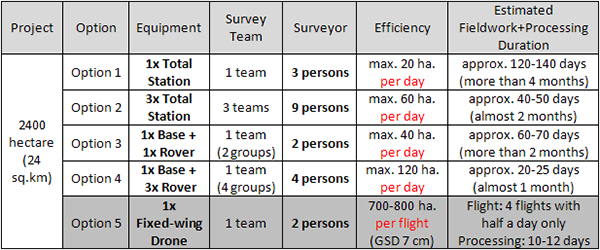
Weighing below several kilos usually and just a bit larger than one toy plane, a professional mapping drone can drastically reduce the labor cost and the time of land surveying that it usually takes with total station or GNSS RTK receiver. For example, you’ve just got a topographic survey project of 2400-hectare (24 sq.km) with comparatively flat terrain for town planning and roadway system development. For this project, your client expects to have a topographic map at 1:1000 scale and contour lines with 1m interval. Basically speaking, you could consider terrestrial surveying by using total station or RTK only in the past decades. However, nowadays you may enjoy a new solution which is more highly efficient. See below:

Note: The estimated durations mentioned above were based on rough calculation for reference and have much to do with the surveyor expertise, processor proficiency as well as weather and terrain conditions. Surveying during bad weather seasons (rainy or snowy days) or working in hilly terrain areas with poor traffic routes would inevitably extend the project time. Therefore, you should consider higher labor costs for a tougher survey job and in other words, you have to pay more than usual. However, with a mapping drone, it will take you 1 or 2 days in the field for data acquisition and 10-12 days in office for post processing. Then in two weeks around you may submit the output result to the client.

From this story, you may easily find that UAV solutions would help to accomplish the survey work much faster, yet with less time and labor. Actually, drone survey just enables you to transform more fieldwork hours to office operation with air conditioning and indoor relaxation which are highly preferred by all surveyors, as nobody would like to stay in the field for long time to get sunburnt, or suffer hard moves in the rain/snow.
The mention of mapping drones may initiate a series of hot topics like survey-grade accuracy, ease of use to surveyors, safe flight control, etc. As a result, some people seem hesitant or even doubt the practicality of drone use in survey work. What is rational is actual and what is actual is rational, said the famous German Philosopher G.W.F. Hegel long time ago. In recent years this controversial technology has proved to have its greater and greater effect in the global geo-information community with a number of successful cases.
What surveyors really care about drone purchase is the quality mapping outputs that can meet survey-grade demand, which is absolutely prior to any other concerns. And a frequently asked question might occur, how to opt for a qualified UAV package? To put it in a simple way, what makes a professional mapping drone that fits for actual survey work?
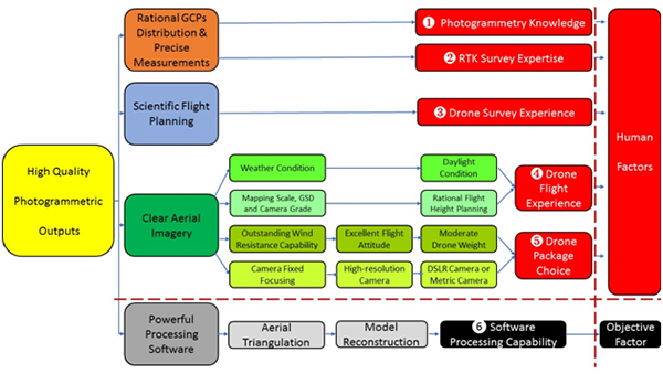
Practitioners have gradually realized that rational GCPs (if necessary) distribution plus precise measurements, scientific flight planning, clear aerial imagery and powerful processing software are the key factors for generating high quality photogrammetric outputs (see below).

The diagram above was made according to the aerial mapping experience of hundreds of surveyors, which might be of good reference to beginners. We may infer that:
① capable supplier or professional survey manufacturer can help users with necessary photogrammetry knowledge.
② RTK survey shall not be an issue to surveyors nowadays.
③ excellent flight control software with intuitive interfaces and instructions would definitely enable the users to take it easy in mission planning.
④ the right timing for data acquisition and rational flight height setting usually result from plenty of drone flight experience.
⑤ the drone weight and equipped camera are very essential in terms of quality aerial imaging.
⑥ after all, a powerful processing software kit is also critical to generate high quality outputs.
In one word, surveyors would enjoy lots of benefits from a good choice of drone package, which consists of nice drone hardware, humanized flight control software and powerful processing solution. Generally speaking, professional survey manufacturers understand very well what surveyors really want and would simply bring out the UAV package solutions tailored to survey needs.

In summary, quality mapping outputs at survey grade are possible when all elements are ready. And the paper intends to deliver this message to those parties interested.


