South S8+C is the Continuously Operating Reference Station (CORS) which consists GNSS multi-constellation tracking performance, including BeiDou Navigation Satellite System, to provide the highest accuracy in positioning and navigating.
NRS is compatible with other brands CORS receivers
Four units of South CORS S8+C have been installed in HongKong Lands Department Satellite Reference station site. ShaTin (HKST), Kam Tin (HKKT), Peng Chau (HKPC) and Obelisk Hill (HKOH) have been chosen to install the South S8+C and to BeiDous network RTK solutions in Hong Kong. The designed network will cover Hong Kong Island, Kowloon Peninsula and Part of the New Territories. At beginning, SOUTH four stations has built up the network, the remaining other brands stations are combined into NRS software to active the coverage.
| |
|
| Four SOUTH stations build up network | Other brands station join into SOUTH NRS |
In order to maintain the normal RTK service for the Lands Department Satellite Reference station, we have used the splitter to split the antenna signal into two different CORS receiver. As a result, South CORS S8+C can test BeiDou network RTK solutions at meantime have the comparison with Lands Department original GPS+GLONASS CORS.
Get accurate fixed GPS+GLONASS+BEIDOU solution among the high buildings
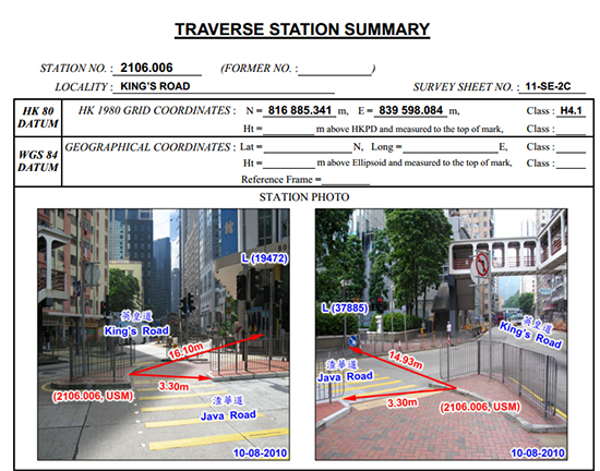
Location: King’s Road (near Hong Kong Funeral Home)
GNSS: GPS (3) + GLONASS (3) + BeiDou (4) <Network RTK>
Instrument: S82V

| |
|
By tracking GPS + GLONASS + BeiDou, even under densely high rise buildings at the crossroad and a poorly opened sky view in King’s Road, a fixed solution can still be obtained.
Although there is a severe multi-path effect and a limited open sky view under this testing environment, by comparing the Easting and Northing of Station No 2106.006 with the coordinates we obtained, the position (Easting and Northing) can get a HRMS 0.023m and VRMS 0.043m accuracy. The PDOP value can also remain in 3.1. This result can never be obtained when only tracking GPS + GLONASS.


